Products
Map
Overlay
Evaluate & Analyse
Basic Subscription Plan
Our cloud-based product revolutionises the way you interact with rural and agri properties, providing unparalleled geospatial insights and a competitive edge.
The Rural-Focused Location Intelligence Platform.
Trusted by the world's top financial
institutions and agri-enterprises

Data & insights for rural industries

Drive an uplift in both sales and quality leads

Strengthen risk management in the face of climate change

Digitise processes, reducing cost to acquire and serve customers

Produce comprehensive, branded digital property reports easily

Gain exclusive insights tailored to your sector

Capture geospatial data for easy reuse across your organisation
The DAS Platform is trusted by industry leaders including insurers, banks, lenders, government, property, rural suppliers, grain, cropping, and valuation.
Individual investors and landholders also use the DAS platform, as do businesses that invest in food and agribusinesses, advisory and consulting, real estate and sustainability-focused organisations of all kinds. It's a game-changer for managing a range of use cases, from determining fair value to mitigating risks, uplifting sales, benchmarking productivity and portfolio planning.
With access to the DAS platform you can:

Discover detailed information about the land, including soil types and crops grown.
Land Use

Gain insights into Potential Carrying Capacity and agricultural productivity.
Farm Output

Get a detailed look at the structures on a property, with assets automatically populated.
Structures

Define property boundaries with precision.
Map A Farm

Create branded, in-depth reports with the content that matters to your business, like relevant nearby sales data.
Digital Property Reports

Access property sales data from the last 10 years.
Sales History

Assess property suitability with rainfall and growing season data.
Climate Data

Access critical data on flood, fire, frost, and rainfall risks.
Risk Assessment

Locate any rural property or hobby farm over one acre in size quickly and easily.
Search
The world's only rural-specific workflow
Testimonials


Access to DAS has enabled us to have conversations about value with our customers that we haven’t been able to have before and provide them with additional information that drives crucial context and insights about their properties

National Property Business Development Manager, AWN
In the past we had found that compiling information was time consuming and sometimes inaccurate, as there were multiple platforms to use. DAS became our one-stop shop platform that gathered all the information we had been using plus more. We quickly found that our clients were impressed with the level of detail we could provide them. It has certainly become part of our everyday process

Director,
Garry Nash & Co
We find [the DAS Platform] invaluable to confirm and endorse comments that owners put forward in relation to their property
Image credit: NASA Earth Observatory
True rural expertise
Take advantage of our premium add-on data sets

Net Primary Productivity (NPP) is the rate at which plants store carbon.
It can be used to quantitatively compare rural properties and farms, even if they are in different regions or states.
For instance, if the long-term mean NPP for one farm is higher than another, then it has grown more plant matter.
NPP

Do you need more data on yield estimates?
Add this Cropping Yield data to your subscription, and gain yield estimates for cropping properties.
It’s updated every month during the season.
Yield estimates are another metric that can be used to market and compare rural properties and farms.
Cropping Yield

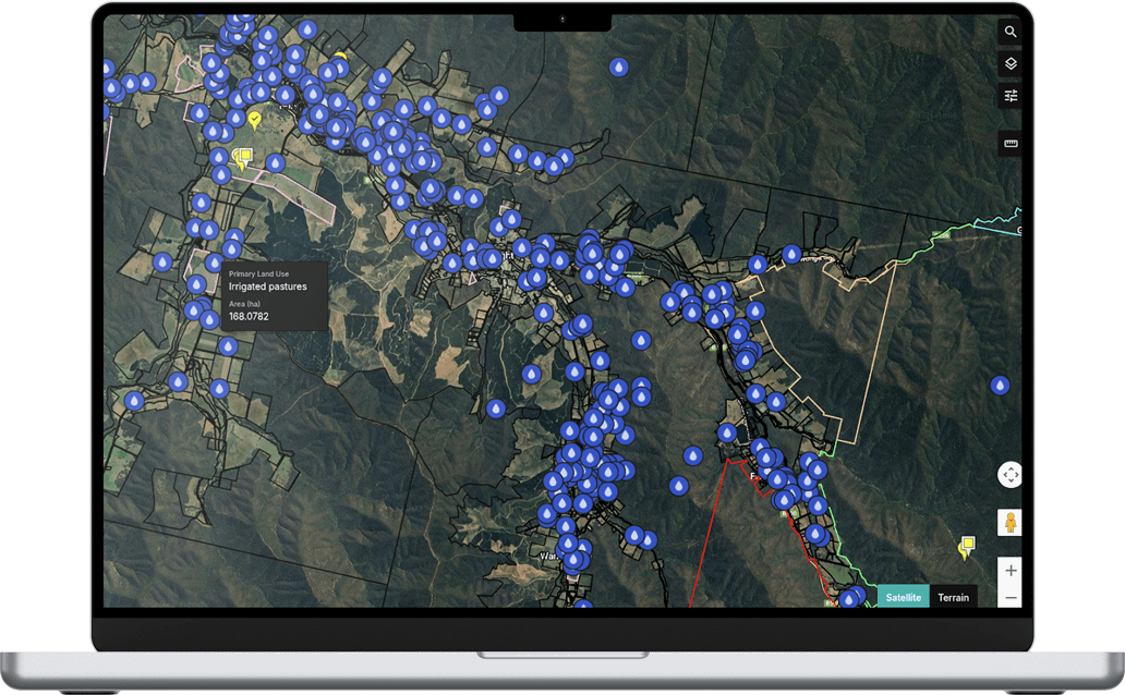
Water Bores

Ready to get started?
Platform access comes with our standard Rural Property foundational workflow. Get in touch or watch a short demonstration video of the DAS platform in action.

Gain even more value with our workflow add-ons

Gives insurers and financial institutions access to advanced data, a powerful agri-insurance centric workflow and digital reporting on any property, delivered instantly.
Rural Insurance

Analyse and evaluate rural-specific property improvements, inclusions and land value, with advanced comparative analysis that supports your organisation’s knowledge and expertise.
Rural Valuations

Our insights, your system
Access our data and insights within your organisation's existing systems via API.


By sharing your email, you agree to our privacy policy and consent to receive email marketing communications from DAS. This site is protected by reCAPTCHA and the Google Privacy Policy and Terms of Service apply.

© Digital Agriculture Services Pty Ltd.
All rights reserved. Privacy - Platform Terms


-v3.svg)